Our Solutions
Explosions in urban areas
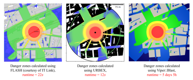
URBEX (URBan EXplosion)
The URBEX project tackles one of the biggest challenges in urban safety: accurately modelling blast wave effects in urban areas. Current tools are either too simple to be reliable or too complex to use quickly in real-world conditions. We are developing a solution that combines accuracy, speed, and accessibility to support urban planners, decision-makers, and first responders.
The URBEX fast-running code, one of the outputs of the research project URB(EX)3, co-funded by the French National Research Agency (grant #ANR-21-CE39-0016), introduces a paradigm shift: a validated, meshless model designed for blast wave propagation in urban environments, accounting for all urban effects (diffractions, regular and Mach reflections, channelling and urban canopy bypassing), while avoiding explicit volumetric discretization. The algorithm enables rapid and exhaustive exploration of the environment, with the near-instantaneous generation of overpressure or consequence maps (within less than a minute on a standard laptop).
The URBEX code aims to decompose the complex pressure signal measured in the study area into a sum of unitary waves. Each unitary wave exists only within a specific spatial domain, where one or more functions describe the evolution of its parameters. The model describes a tree of unitary waves, where the first level corresponds to the initial “free-field” wave, and the next level includes the unitary waves resulting from the reflections and diffractions of the waves from the previous levels. The higher the precision level, the more accurate the results will be.
The mathematical method is described in patent FR3158819, already published in August 2025, and has been presented at the 17th International Conference on Structures Under Shock and Impact (SUSI 2025) and will be presented in the 27th International Symposium on Military Aspects of Blast and Shock (MABS 27). This approach enables rapid and reliable calculation of the consequences of an explosion in urban areas, supporting effective operational decision-making.
URBEX is based on a geospatial representation of buildings, compatible with commonly available data (OpenStreetMap, SwissTopo, etc.). It generates mapping of effects (overpressure, eardrum rupture, lethality, glass breakage, etc.). URBEX is accessed through an intuitive interface where the user sets the explosion, adjusts the charge, and instantly views the effects map, with options to switch between consequences.
URBEX enhances the accuracy of risk zone estimation, reduces false alarms, accelerates intervention planning, and improves overall operational safety. It fills a critical gap between empirical models and advanced simulators that are unsuitable for field constraints. Unlike traditional approaches, the model requires neither prior meshing nor volumetric solvers. It offers a perfect balance of speed, accuracy, and user ergonomics, providing non-specialist operators with a simulation tool previously reserved for experts. URBEX thus contributes to better estimation of dangerous zones while optimizing the effectiveness and rigor of interventions in urban contexts.