Birth of the project
The ANR DEMOCRITE project was born from preliminary work carried out by the Paris Fire Brigade (BSPP) with the help of trainees from the Ecole Polytechnique. The idea was then to conceptualize a Risk Analysis and Coverage Engine (MACR) with a view to anticipating operational needs.
The MACR pre-project, supported by Major Stéphane Raclot (now Colonel), was then transmitted to LABEO, a joint laboratory between the Paris Police Prefecture and the CEA/DAM (French Atomic Energy Commission – Military Applications Directorate). Régis Guyonnet (LABEO and CEA) and Guillaume Schlumberger (at that time Director of Foresight and Strategy at CEA/DAM) proposed to seek ANR (Agence Nationale de la Recherche) funding to assess the feasibility of a software platform integrating operational RETEX, rapid models, and on-the-fly mapping.
The first step was the choice of a CEA/DAM center capable of building and carrying the research project. The Director of the CEA Gramat center at the time, Didier Besnard, attracted by the project and eager to open the Gramat center to the outside world, circulated the request and the file ended up landing… on my desk. I picked it up with enthusiasm, being more or less specialized in 5-legged sheep!
I had some possible partners in mind, and some answers to bring to the needs expressed by the BSPP. The idea of spatio-temporal development of events on a grid (“operational tiles”) immediately made me think of approaches by cellular automata or “small world” networks (an approach that will be effectively developed in the “macro” fire model of DEMOCRITE).
I defended these initial ideas before the CEA/DAM and LABEO, and I was officially “knighted” to carry the project. The second step was to present these ideas to the BSPP. As they were very close to what Stéphane Raclot had imagined, the current immediately passed between us, as well as with Lieutenant (now Captain) Floriane Brill, the very dynamic person in charge of the GIS (Geographic Information System) team .
At this stage, all that was left to do was to set up the project.
From MACR to DEMOCRITE
From MACR to DEMONSTRATE an ANR project “from scratch” is a real race against time… It was necessary to define the main lines of the project, find the relevant partners, collect the technical proposals and the figures of each one, arbitrate and modify… then iterate until obtaining a coherent and financially viable project. The CSOSG (Concepts, Systems and Tools for Global Security) call for proposals was published at the end of January 2013, with a deadline for submissions in early April.
The objective of the project was clear: to develop a risk analysis software platform compatible with the BSPP GIS data (integrated in the common police / firefighter GIS base), and taking into account:
- the firefighters’ experience feedback (around 500,000 interventions per year, geocoded at the track section and coded according to the CRI: Code Retour d’Intervention), which gives an idea of the probability of occurrence of current risks (a posteriori),
- Mapping of issues, intrinsic vulnerabilities of the territory, in order to have the second dimension of risk,
- rapid models (i.e. compatible with operational use) for certain complex risks.
For rapid models, the risk of explosion in an urban environment (attack or accident) was in line with the CEA/DAM’s competencies (and mine!), and was also of interest to the SGDSN (General Secretariat for Defense and National Security) and the DGA (General Directorate of Armament), recently partners of the ANR (French National Research Agency) for co-financing CSOSG projects.
Another major risk needed to be addressed. We rejected the idea of modeling the flood risk, which is extremely complex to deal with in Paris and the Ile de France region… The fire risk (uncontrolled, i.e. without intervention by the emergency services), on the other hand, seemed accessible to rapid modeling and corresponded to an emblematic activity of firefighters. In order to set up a rapid model of fire propagation between buildings (island fire), it was necessary to find a partner capable of finely modeling these phenomena in order to determine simplified laws: laboratory P’ in association with IRIAF (Institut des Risques Industriels, Assurantiels et Financiers) accepted the challenge of numerical modeling of building fires.
Feedback mapping was to illustrate the average operational activity over a given time period, by refining the analysis by type of intervention (the famous CRI codes). The representation chosen by the BSPP was the projection of the data on a 200 m x 200 m operational grid, which also corresponds to the finest granularity of INSEE data.
Concerning the issue mapping, human vulnerability was of course the priority. I had worked with the Ecole des Mines d’Alès (now IMT Alès) on this topic a few years before, and it seemed possible to go further than the day/night vulnerability distinction used then. We had also worked on psychological and media vulnerabilities, but these areas do not lend themselves to a fine, infra-urban granulometry. In line with numerous works on essential urban services, we therefore decided to study the functional or social vulnerability of the territory, in the sense that society is based on the fulfilment of essential functions (education, health, transport, energy, etc.) that can be disrupted by a hazard. We logically chose the same 200 m x 200 m grid as the one used for RETEX.
In order to integrate these maps on the fly, we called upon the SYSTEL company, leader in alert systems for fire and rescue services. SYSTEL had previously developed a tool, the Risk Modeling Tool (RMT), capable of hosting map generation tools.
We also integrated a joint INRIA / Ecole Polytechnique (CMAP) team in order to link up with the work of the MACR tool and provide independent advice and guidance on the scientific approaches chosen by the partners during the project.
The Human and Social Sciences aspect of the project was quite naturally entrusted to the CERDACC (European Research Center for Collective Accidents and Disaster Law), already well known to the BSPP. The themes chosen were directly linked to the BSPP’s questions: on the one hand, the notion of “risk pool”, which can transcend the usual administrative limits (which also correspond to the different levels of crisis management); and on the other hand, the notion of “rescue law”, an important point linked to the growing judicialization of society which leads some people to sue the rescue services…
Last but not least, it was necessary to find a company capable of integrating all these tools, models and cartographies… with the constraints of an ANR project (the maximum rate of aid for SMEs was at the time 45%, which can put off some companies). My wife, Christine Lapébie, had had very good relations with the company IPSIS (now IT Link) during previous projects (in her position at CEA/Gramat and before that at DGA/Techniques Terrestre). IPSIS, accustomed to working in the field of Global Security for projects integrating mapping and modeling), has accepted to be the integrator of the DEMOCRITE project.
The consortium was ready, and the project could be submitted on time (I’ll pass you the details, it wasn’t as easy as that and the scientific document of the project was amended until the last days before the deadline).
Validation of the project
We were quite confident in the ability of the DEMOCRITE project to be retained by the ANR: the subject was relevant in view of the priorities of the call for projects, the partners were complementary and recognized, the project itself was innovative, integrated operational people, brought a real added value compared to the existing one, and it had been labeled by the Risk cluster (now SAFE cluster).
The previous CSOSG 2012 edition financed 12 projects for a total of 9.04 million euros. For the 2013 edition, DEMOCRITE came 7th out of 22 projects submitted… for only 6 projects selected on the main list, the budget having decreased to 5.9 M€! Fortunately, DEMOCRITE, first project of the complementary list, could be retained after financial negotiation and thanks to the support of the DGA (Monika Meyrieux) and the SGDSN (François Murgadella).
The main characteristics of the project in its validated version :
- 8 partners,
- T0 set for start-up: March 1, 2014.
- 48 months initial term, extended by 7 months,
- 995 k€ of ANR+SGDSN+DGA support,
- a total budget of approximately €3.5 million,
- 249 persons.months of permanent staff,
- 61 persons.months of non-permanent staff (CDD, PhD, post-docs),
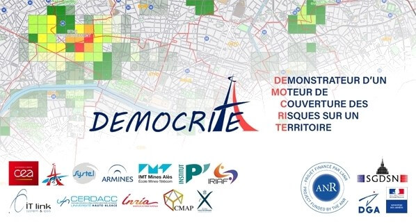
But by the way, why DEMOCRITE? First of all because it is the acronym of “DEMOCRITE, a DEmonstrator of a RISK COVERAGE MOTION on a TErritory” (a rather premonitory title, the initial project being rather focused on risk analysis, and not coverage, but I won’t spoil the rest of the articles…). And because Democritus was a Greek philosopher, one of the first “atomists”, considered as “the most scientific of Greek philosophers” (Wikipedia!) and known to have an encyclopedic knowledge on extremely diverse subjects, which represented well the integrative character of the DEMOCRITE platform and the possible opening to other fields!
More in a next article!